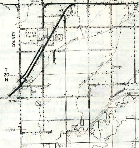
Where on Earth is Heelstring?
(Technically, 36, 21', 13" N by 90, 41', 40" W)
Heelstring is located about five miles southwest of Corning, and about three miles east of Reyno, Arkansas. To the northwest is the little town of Datto. Having never had a post office, Heelstring is therefore not a town or village, but a farming community. Now the area is mostly open farmland, criss-crossed with fencerows and irrigation ditches, but decades ago there were forests separating the fields.
"Heelstring" is a common name for the Achilles' Tendon. There are two legends of how the area southwest of Corning acquired the name of 'Heelstring'. The first is that the residents danced and partied so much on Saturday nights that they were unable to go to church the next morning because their "heelstrings were sore". The second is derived from the effect of the thick, black mud (known as "gumbo") in the bottomlands of the nearby Black River on the Achilles' Tendon. It was said that "walking in that gumbo sure makes my heelstring sore."
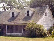
"The Farm"
The location known in the Park family as "the farm" was on Heelstring Road one-fourth mile west of Murphy Lake Road. The farmhouse was built of solid cypress by George William Sherad Watson about 1901. The original structure was two rooms wide, with a breeze-way, or "dog-trot" behind the left room, and a kitchen on the far side of the dog-trot. A porch spanned the front and another one which was L-shaped was in the rear.
In 1938, a new room on the front left was added and became the new kitchen. The front porch was extended across the new kitchen, much to the delight of visiting youngsters. Also at this time, electricity, indoor plumbing, and a bathroom were added.
Murphy Lake
Murphy Lake lies at the south end of Murphy Lake Road, four miles south of U.S. Highway 67. In the 1930s "it was known to not have a bottom", because no one could swim deep enough to touch the bottom, or perhaps because few bodies of water are muddier, no one was interested in swimming to the bottom. In the 1920s, someone lowered an iron tied to a bed cord over the side of a boat in the middle of the lake and the iron never touched the bottom. Or perhaps because few bodies of water are muddier, no one was interested in swimming to the bottom. But chances are this lake was originally deeper than anyone imagined.
If one looks at a map of western Clay County, it will be noticed that the few natural lakes in the area, such as Long Lake, Woolfolk Lake, Corning Lake, and Victoria Lake, all are rather long and narrow, and all lie on a southwest/northeast axis. When compared to charts which show ground fractures created in the New Madrid earthquakes of 1811-1812, it is possible that these lakes are fissures which have filled with water.
Sediment is continually being washed into the bed by Cypress Ditch at the northeast end in addition to the numerous gullies in the surrounding fields. Over the decades this sediment has built up on the bottom until one can touch bottom with a six foot pole anywhere on the lake. Since dredging is an expensive alternative with no monetary return, and farming most likely will continue, Murphy Lake will probably become a marsh before filling in completely, at which time it will be converted into farmland. The lake could disappear in as little as fifty years.
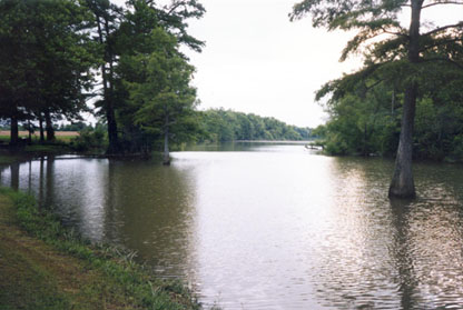
Taken July 4, 1997 at high tide.
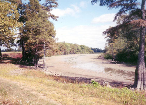
Taken in late October, 1999 during a low tide.
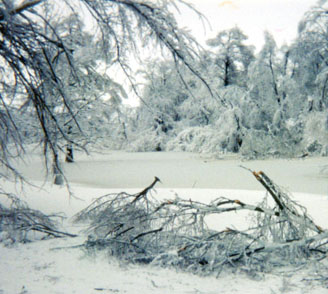
Taken January 17, 1994 after the ice storm.
Hopewell Baptist Church
The Center of Heelstring*
Hopewell Baptist Church was organized in 1886 after an 1883 report on "destitution" was made to the Current River Association that the "community known as Heelstring was almost or entirely without Baptist preaching". In 1886 Hopewell reported 16 baptisms and a total membership of 29. Thomas Jefferson ("T. J.") Watson was clerk, and Gideon Townzen was pastor. The next year T. J. Watson was pastor. Sometime following this date the church ceased operation, and on 2 Aug 1908, it was reorganized with the following members: G. W. S. Watson, J. H. Irwin, Hulday Griffin, Lizzy Griffin, Joseph Warren, J. W. Brown, M. L. Russell, Mrs. M. L. (Barbara) Russell, Jane Wilson, and Mary Brown. The minutes show that this new start was due to mission work done by T. J. Watson, who with the assistance of Anderson Berry, a deacon in the Datto church, effected the new organization. Thomas Watson's wife, Mary Dixon Watson, is credited for naming Hopewell when she stated at its organization, "I hope it goes well."
The church has had three houses. The first was about one-half mile north of the present location. On 5 Sep 1911, a one-half acre site was bought from Benjamin Hudson for $15, and a one room frame building was built. This church was destroyed by fire on 1 Dec 1929. A new house was built in 1930 for approximately $3,000 under the pastoral leadership of Hubert Willis Johnston. On 22 June 1930 the new house of worship was dedicated with Knox Belew, a former pastor, preaching the sermon.
Other pastors who have served this church are M. V. Hinson (1889), T. B. Baker (1896), C. A. Fowler, S. N. Dickinson, Bill Woodson, Wade Hopkins, and C. F. Gwinup (1941). In 1947 the membership was 198. Robert Johnson, who was at that time pastor of the Baptist Church of Caraway, was ordained to the ministry at Hopewell. The Current River Baptist Association met at Hopewell in 1893, 1927, 1937, and 1946.
*According to the U.S. Geological Survey.
Indian Graveyard
Legend has it that there is a small Indian graveyard on Heelstring. It is located about 3-3/8 miles south of U.S. Highway 67, on Murphy Lake Road. On the east side are two large trees in the field. The graveyard lies in the shade of the southernmost tree. Thomas Huggins, son-in-law of G. W. S. Watson, owned the land at one time, and never farmed under the tree, keeping the spot sacred.
Heelstring Memories
In 1943, Mrs. Robert (Marie) Johnson wrote a series of three articles for the Clay County Courier depicting an imaginary trip through Heelstring. Mrs. Johnson named the residents at various homes in a route first traveling southward down Heelstring-Murphy Lake Road, then heading westward toward Reyno. The stars mentioned in the article refer to the WWII custom of hanging stars in windows to show the number of household members serving in the war.
If you have a particular memory you'd like posted on this page, please e-mail me at S_cotStout@aol.com (remove the underscore after the first letter before e-mailing).